















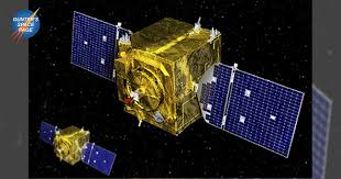
The Defense Innovation Unit (DIU) has launched an ambitious initiative: the acquisition of commercially produced satellites capable of capturing high-resolution images of other spacecraft in geosynchronous Earth orbit (GEO). This is a strategic move designed to revolutionize how the United States monitors its assets and potential adversaries in space, at a crucial altitude of approximately 36,000 kilometers.
GHOST-R Mission: Near Real-Time Space Monitoring
The new program, named Geosynchronous High-Resolution Optical Space-Based Tactical Reconnaissance (GHOST-R), primarily aims to rapidly place into orbit a capability to survey, in near real-time, both „adversary” and „friendly” satellites. The unit explained that these images must be detailed enough to allow the discernment of the purpose and functionality of each observed space object. The objective is to gain unprecedented insight into the space environment.
The Commercial Advantage: Efficiency and Reduced Costs
A crucial aspect of this solicitation is the DIU’s desire to achieve this at a significantly lower cost compared to the Space Force’s current space domain awareness (SDA) programs for GEO. These include the venerable GSSAP (Geosynchronous Space Situational Awareness Program) constellation and its planned successor, known as RG-XX. It is anticipated that commercial satellites will „reduce costs compared to existing and planned programs,” while simultaneously providing „high-resolution image collection, allowing for increased collection frequency and detailed characterization of resident space objects (RSOs) in GEO.”
Draconian Requirements and Tight Deadlines for Suppliers
Interested bidders face a series of technical and logistical challenges. Within 24 months of a contract award, they must deliver a „minimal viable product” (MVP), consisting of a „high-resolution electro-optical (EO) image” of a GEO-stationed satellite, using a „commercially operated space vehicle.” The required resolution is precise, capable of identifying a medium-sized satellite (approximately 700 kilograms) from a distance of „no closer than” 10 kilometers.
Furthermore, within 36 months, the winning vendors must be able to transition their satellite and ground operations from a contractor-owned/operated system to a government-owned/operated one. Finally, within 48 months, the satellite must demonstrate the ability to perform at least one pass per week by a target spacecraft during the first year of government operations. The proposed satellites must meet Department of Defense cybersecurity requirements, be designed for a three-year lifespan, and the bus and primary payload systems must demonstrate „proven space heritage” by 2028. Competitors also need to present a plan for scaling up a constellation capable of maintaining a „30-day revisit rate” for every GEO space object listed in US Space Command’s public Space-Track.org catalog, over a 10-year period.
Strategic Impact: From Characterization to Battle Damage Assessment
The success of this initiative will have profound implications for the United States’ defense and intelligence capabilities in space. The DIU emphasizes that „the successful deployment of these capabilities will significantly improve GEO RSO Characterization, Battle Damage Assessment (BDA), Positive Identification (PID), and Combat Identification (CID).” Essentially, the Pentagon will have a much clearer and faster „look” at any activity in geosynchronous orbit, an increasingly contested domain.